Sunday, December 27, 2009

Marten Creek

December 26, 2009

We were hoping to get to do some snowshoeing the day after Christmas, and the guidebooks offered up Marten Creek as an off-the beaten-path narrow meandering forest trail rich with wildlife. Cougars were mentioned. Alas, we spotted no wildlife -- not even a squirrel -- and there was only a dusting of snow, but Martens Creek is indeed secluded and darn pretty.

Marten Creek is in the Alpine Lake Area, and only a little over an hour's drive from Seattle. There is parking along the road on both sides. We arrived at the trailhead a little over 10:00 and started suiting up. True to its secluded description, there were no other cars parked there, and we only saw one car go by the entire time we were getting ready. Since this was our first attempt at snowshoeing we had to grapple with gaiters and mittens and figuring out how to strap our snowshoes to the packs.

The trail starts with some long, steady switchbacks. It's definitely a serious uphill, but nothing too crazy. However, I'm just getting over the infamous H1N1 Flu and was surprised at how winded I got on this portion. I also got extra hot, also a result of being not quite well, so it was a sweaty, wheezy, uncomfortable start for me. I kept telling myself I was sweating the last of the virus out :)

The trail more or less levels off after about a mile. Though there had been a dusting of snow on the road where we had parked, everything along the trail was completely barren of snow. It was rather warm too, and getting warmer as we walked, so we were stuffing gloves and hats into packs as we went. Every description we had read said that there was almost always snow here, even if the first bit of the trail didn't have any. But the further we got, the less likely it seemed that we were going to see any snow.

Marten Creek has some interesting history to it. In the late 1800s and early 1900s, prospectors discovered ore at the head of Marten Creek. The trail is actually an old miner's path that used to link to Granite Pass. The mines never produced much, and the area was abandoned. There was also a big forest fire here in 1897, and the Forest Service used the area for a plantation project, planting seedlings from various areas in marked groves in 1925. There's an interpretive sign not too far from the beginning of the trail, explaining the experiments.

You are definitely in the woods here. Though it was early in the day, portions of the trail were just dark. I was reminded of all the forest myths about the dark and mysterious nature of the forest an the creatures that resided there, and more than once I was reminded of the line from Frost's poem, "The woods are lovely, dark, and deep."

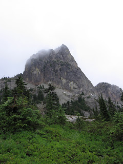
As we got a little further on, we had a great view of the peak at one end of Gordon Ridge, and, in the distance, through Granite Pass you could see the jagged peak of Three Fingers. As we went further along the trail, it got noticeably colder, and the hats and gloves came back out. We started seeing snow, and were hopeful that we might actually get to do a little snowshoeing, but there was never more than a few inches of snow on the ground. Snow covered branches did make for some beautiful winter scenery.


The trail got much wilder as we neared the end. There were lots of downed trees, and snow covered brush that would sprinkle snow down your neck as you passed by. At one point in the trail, the easiest way ahead was to slither under a couple downed trees on my stomach, army style. Eventually, the trail runs into the creek and just sort of peters out. I have to admit, it's sort of an unsatisfactory ending to a hike -- no summit, no lake, no sign -- we just sort of looked at each other and shrugged, as if to say, well I guess that's it.

We were disappointed we didn't see any wildlife, and of course, that there wasn't any serious snow, but we did have two rather exciting moments. As we neared the end of the trail at the creek, we heard some loud popping, almost like gunshots, followed by a deep rumble. We thought it was an avalanche on a neighboring mountain. Later, as we were just back to the parking area, we heard a similar popping sound and Michael actually saw the top of a huge evergreen get sheared off. There were some incredibly powerful gusts of wind as we came off the trail and a wind advisory was in effect. So, what we thought was an avalanche earlier might have been some cracking and falling trees.

All in all, it was a nice winter hike. This is definitely a deeply forested and secluded spot, and we'll have to come back when there is some real snow to give it a run in showshoes.


Directions: From Granite Falls drive the Mountain Loop Highway about 9 1/2 miles past the Verlot Public Service Center and look for the Marten Creek trailhead on your left, beyond the Marten Creek bridge, at an elevation of 1,415 feet.


Monday, November 02, 2009

Cathedral Rock - Deception Pass Loop with Jaunt to Tuck's Pond and Robin Lakes

August 14 - 16 2009

We've done some incredible backpacking trips during our first summer in Seattle, but this one, which took us through misty forests and landed us high in mountain goat territory, ranks as our best hike so far. This 14 mile loop through the Alpine Lakes region has amazing scenery and challenging switchbacks on its own, but what makes it truly spectacular are the many side trips off of the loop, which lead to some really breathtaking spots.

Route 4330 is a bumpy, excruciatingly long dirt road in to the trail head. As we wound our way around the potholes I was waxing on the joys of an old 4WD pickup, but we definitely made it fine in our Mazda. We passed by a bunch of nice riverside campgrounds and campgrounds, and eventually made it to the trailhead.

The first thing I noticed in the parking lot was that it was cold, a lot colder than it had been. I'm still getting used to these west coast mountains and their impressive elevation gains. The second thing I noticed were all the horse trailers. The owners of one of these horse trailers chatted us up in the parking lot, and we found out that this is a popular spot for horse camping, as horses are allowed on many of the trails. This seemed pretty cool, until I realized a few hours later that horses that walk on trails also poop on trails, and since trails are narrow you spend a lot of time navigating your way around poop.

We did the loop clockwise, heading up to Squaw lake and Cathedral Rock first. A bunch of guides seem to recommend this for two reasons: you get the switchbacks out of the way first, and you avoid the many crowds that come in by way of the very flat trail that leads counterclockwise to Hyas Lake. Some steady switchbacks took us up 1000 feet and about 2 and a half miles to Squaw Lake, a translucent emerald green mountain lake.

From there, the trail heads more gradually uphill another 100 feet over 2 miles to Cathedral Rock. The forest got denser, and we started to catch glimpses of Cathedral Rock. The misty morning held the top of the Rock in clouds, but they passed just long enough to get a good picture. I can vouch that this rock was indeed named accurately -- rocks and mountains get so many crazy names but on this one I could definitely see the cathedral with spires stretching up into the sky.

Right as we came up on the Rock we bore right onto the Pacific Crest Trail, which was one of my favorite parts of the trail. The trail flattened out, wandering through meadows and woods, and wildflowers, and offering up some awesome views up to the surrounding mountains and down to Hyas Lake.

We ended up making camp just before Deception Pass, at a tiny pond. The pond is the tiny unmarked blue splotch just before Deception Pass, and there is a nice spot for a tent between the trail and it. We had been a little worried about bugs as there had been recent reports warning of mosquito feeding frenzies in the area, but we didn't have much of a problem and the pond worked out well for pumping water.

We wanted to do a side trip for the day, and decided in the morning to hike up to Tuck's Lake and Robin Lakes. We knew it would be steep, but we hadn't read up much on the actual hike, so we didn't have a good idea of what we were in for. The trail up to the lakes is pretty much just a steep scramble up the side of a mountain. We passed a woman hiking up with her daughter who said, "They weren't kidding when they said straight up." That made me feel a little better because I was dogging it. Hiking entails a lot of uphill climbs, but this one was really steep and unrelenting, and you had to watch your footing in the rocks. 2 miles and 1,000 feet gain brought us to Tuck's Pot and Tuck's Lake, an idyllic pair of bright blue lakes surrounded by rocky cliffs and evergreen trees. I sort of wanted to stop right there, eat my lunch, take a long nap, and forget all about Robin's Lake. I even began to wish we had brought our packs, because I liked the idea of staying in this wonderful place and hiking no further.

But after a short water break and some pictures, we headed on up the trail to Robin's Lake. This is where is started to get a little confusing -- there are tons of paths crisscrossing the perimeter of Tuck's Lake and Pot, leading to campsites, down to the water, and up to good viewpoints. We kept losing the trail and ending up circling around various campsites. We finally figured out that the trail heads out between the Lake and Pot, passable over a logjam.

At this point, the path basically turned into a rock scramble over huge boulders. I loved watching Tuck's Lake get smaller and smaller as we climbed higher and higher, seemingly straight up. The path from Tuck's Lake up to Robin's Lake is basically another 1000 feet of elevation gain in 2 miles, but scrambling over the huge rocks was a lot more fun than slogging up the rocky path to Tuck's Lake, and the views on this part of the trail were just stunning. (I run out of adjective for some of these hikes!)

The trail got so rocky that there really wasn't a trail anymore, just a series of cairns to follow. A lot of alternate routs have been carved out from cairn to cairn, so everyone we ran into was always asking, "Am I on the trail?" We finally figured out that all roads were leading to the Robin Lakes, so we stopped worrying about it. We had to push Cody up in a few dicey spots.

Finally, the rocks leveled out a little more, and we came out on Robin's Lake. If Tuck's Lake was idyllic, then this place would be a sort of paradise. Huge white cliffs rising up around these absolutely clear blue lakes. I kept thinking about Heidi going up to the mountains to get well. We even saw a couple mountain goats. We'd gone from dense forest to mountain goat territory in just a few very steep miles.

While it's a pretty magical place to camp, it's worth mentioning that because of the huge cliffs, there are limited spaces for camping around the lakes. And, on a Saturday evening, the place was definitely filling up. You can sense that this is a place in need of protecting. Longtime Northwest hikers Ira Spring and Harvey Manning advise filling your water bottle at the lakes and then retreating to camp away from the lake in a nook or on a ridge -- and to "only camp in this neighborhood of Heaven when essential to your soul."

The last day was a fairly easy hike out, thankfully, since we were pretty knackered from the vertical climb the day before. The last few miles really flatten out along the 2-mile long Hyas Lake. Apparently, this is the go-to destination for young families, who come here to break in small kids, and we passed tons of families camped along the lake on our way out. We smelled a whole lot of pancakes and bacon frying. For an introduction to camping, you could do a lot worse than a hot breakfast at a pristine mountain lake.

As a bonus, we stopped in Roslyn (where Northern Exposure was filmed) on our way out, checked out their Sunday Farmer's Market and had a post-hike veggie burger, fries, and onion rings at the Brick.

Directions: Drive east from Seattle on Interstate 90 to the Roslyn exit, and follow the road north past Salmon La Sac campground. Keep going north on Fish Lake Road (#4330) until you get to the end of the road and the Hyas Lake/Deception Pass trailhead.

Day Hike to Copper Lake

July 11, 2009

We came to the Foss Lakes in the Alpine Lakes region years ago when we were visiting a good friend here in Seattle. We had never hiked to an alpine lake before, and the vision of the translucent green lakes surrounded by mountains and covered with ripe blueberries stayed with us as we contemplated a move to Seattle. So, we decided to revisit our camping spot at Copper Lake on a day hike.

A few things have changed since our last visit -- there was a big rock slide, and there was a sign that said the trail is no longer being officially maintained. This meant a lot of overgrowth on the trail, making it tricky to keep your feet on the path in narrow spots, and some blowdowns. So a lot of extra rocks and vegetation made for a wilder, rougher go of it.

Still, I think this is one of my favorite hikes -- I love lakes, and this hike has one after another. The trail begins as a rocky creek bed, hits a river crossing at .5 mile (we had no problem but I've read this crossing can be tricky at times), and drops you at Trout Lake at 1.5 miles.

It's a good idea to enjoy Trout Lake for a few minutes, because after Trout Lake you hit some gruesome switchbacks, which bring you up 2000 feet to Lake Malachite and then Copper Lake. The trail continues on to Little Heart Lake, Big Heart Lake, and Angeline Lake, but for us, Copper Lake made a fine turnaround point for a day hike.

We met an old timer at the lake out hiking by himself. He must have been in his 70s. He was telling us all about the plants to watch out for in the Northwest. (Oh Devil's Claw -- I see now how you earned the name!) We kind of kept an eye on him at a stream crossing on the way down, but he made it across just fine. Seeing him got me thinking about how I hope I'm still out hiking the big mountains when I'm his age.

The rough terrain made the descent a little trickier than normal, in addition to already being tired from the hike up. I did this in trial runners, but was wishing I had worn boots. We felt pretty wrung out -- but happy -- by the end of it. I'd love to do another backpacking trip here, taking a weekend to explore all the lakes.

Directions: Drive US 2 east to the small town of Skykomish. Continue east for 1.9 miles (passing the Forest Service ranger station), and turn right onto Foss River Road (Forest Road 68). Continue for 4.7 miles (the pavement ends at 1.1 miles), turning left onto FR 6835. Follow this road for 1.9 miles to its end and the trailhead (elev. 1550 ft).

Monday, September 28, 2009

Day Hike to Noble Knob near Mt. Ranier

Noble Knob is a mellow day hike with spectacular views of Mt. Ranier. It's only 7 miles out and back, with only 500 feet of elevation gain, and is perfect for an afternoon when you feel like getting out on the trail, but aren't up for any brutal uphill climbs. The dirt road up to the trailhead is steep and narrow -- passable in a regular car but definitely more enjoyable in a 4 wheel drive. This is mountain bike territory, so you definitely need to be on the lookout for bikers as you wind your way up to the trailhead. Turn left when you see the sign for 1184. The trailhead is now to your right, near the back of the parking lot.

This area was hit by wildfires back in the 60s, and is supposed to have amazing wildflowers if you come at the right time. At the end of September there weren't many wildflowers, but the blueberries were ripe. The red and yellow bushes looked spectacular against the evergreen trees. You only have to meander along this trail for about a mile to be rewarded with an impressive view of Mt. Ranier. I say impressive because the mountain looks strinkingly large and close -- close enough to make out crevasses in its face. A couple mountain bikers rounding the trail and getting a first glimpse of the mountain shouted, "No way!" several times. And it is hard to take your eyes off of it as you hike. Luckily, a little further down the trail is an outcropping to the left with an even better view of the mountain. This is the money shot opportunity, so get out your tripod or find a passerby to take your pic.

At about the 3 mile mark, the trail splits three ways. The left fork descends to George Lake and the right fork past Lost Lake to the Greenwater Trail. You want the middle trail, which winds around and around the knob to the top. The 6011-foot Noble Knob is replete with more amazing views of Mt. Ranier and the surrounding mountains.

Thursday, July 02, 2009

On the Big Quilcene Trail to Marmot Pass and Buckhorn Lake

June 26-28, 2009

This was our first hike since moving to Seattle, so expectation were high. Oh, the hours spent pouring over our "100 Classic Hikes in Washington," talking to people in gear shops, and stocking up on trail maps. Oh, the anticipation as we set up a staging ground of packs, sleeping pads and cookware in the basement. And finally, the very long drive up a long, bumpy road as the air outside got colder and colder. Luckily, Marmot Pass did not disappoint.

One thing we quickly learned as we were selecting our hike is that because of the high elevation of the mountains here and the resulting snow, the hiking season here is a lot shorter. The Guidebooks here give general guidelines for when the trails are clear enough to hike, and you can call ranger stations to get more accurate reports. As it was, we did this hike at the end of June, as still encountered snow covering parts of the path. So, when summer hits, it's like this small window of time to hit all of the incredible hike sin the big mountains.

The other thing we learned on the trip is that it is cold in there mountains -- even at the end of June. This is a complete departure from hiking the smaller mountain around DC, where it gets so hot and humid in the summer that many people don't even backpack during the hottest summer months. Though we knew it would be cool in the mountains and had a general idea of the temperatures, we were having a hard time conceptualizing just how cold it would be. Our first real indication was when the ranger told us that it was getting "down in the 40s up there."
Our second indication of just how cold it would be was when we got to the trailhead and stepped out of the car. We could sort of see our breath. It was just hard to believe that this was summer.

The trail starts out in intensely green forest. We were immediately surrounded by towering conifers, mossy rocks, spongy soil, and a pine needle-covered trail. Lush is the word that comes to mind. It had that primordial feel to it -- as if a dinosaur could have crossed our path and it wouldn't have seemed that out of place.

The trail went up and up, right from the start. It was never super dramatically steep, but we were definitely gaining elevation and the occasional flat stretches never lasted long.


At two and a half miles and 3600 feet we reached Shelter Rock Camp. After this, the pine needle trail turns to rocks, and you;re suddenly in meadows of wildflowers. Except that the meadows are not flat -- they're on the sides of mountains. I coined the term "vertical meadows." Purple, orange, and yellow flowers everywhere. I had a new appreciation for the old poets who waxed on the serene beauty of meadows.

Along the way, we got an impressive peek at the neighboring mountains, with their tops enveloped in clouds.

After two more miles and another 1800 feet elevation gain (the guidebook referred to this as "Poop -Out Drag"), we came to Camp Mystery. The trail flattens out, and suddenly you are surrounded by campsites all around a creek. We had heard there wasn't much water higher up, so we decided to bed down there for the night. We decided to take a peek at what was across the creek and discovered a secluded campsite on just the other side of the creek.

This is where I must make a confession. We had seen signs that said no campfires were allowed at this elevation. But campfires are sort of an integral part of our camp evenings, and after we made dinner, we were sort of at a loss as to what to do with ourselves. And did I mention it was cold. We were, perhaps, not quite as acclimated or outfitted to the weather as we should have been. Then Michael came back from a scouting trip to report that he had seen others making fires. Well, maybe fires were allowed? I think we may have sort of talked ourselves into this. Anyway, you see where this is going -- we made a fire and had happily been warming ourselves beside its warm goodness when we got a visit from the Good Samaratin Club. They were very nice, and I actually appreciate that they were protecting the trees, which are very old. (As a side note, they seemed quite impressed that were were able to make a fire from such damp wood.) So, we put the fire out and I'm happy to report we have not made one at high elevation since.

The next day was sunny and clear, and we decided to do a hike from our base camp to Buckhorn Lake. As we left Camp Mystery, the trail wound its way through more woods, and then were were suddenly in this huge basin of grassy fields. There were trees on either side, and a cliff straight ahead of us. Not much further past this, we came to Marmot Pass.


Suddenly there seemed to be people everywhere. A woman was asking people if we had seen her husband, and another couple asked us if we had been here before as they were trying to decide where to go. There's a crazy signpost at the Pass, and several trails leading in various directions. After we'd talked to all these people we finally looked up and saw the snow-capped Olympics straight in front of us. It was a breathtaking view. (I'm using up all my superlatives on this hike.)

We headed right on the Tubal Cain (#840) towards Buckhorn Lake. We were literally walking on a path cut into the side of a mountain. At one point there was snow covering the trail so we had to carefully inch our way over the snow to get back on the path. Then we came out on the top of a mountain. It was rocky and barren, like a moonscape.

We walked for a while over these trails, which was pretty surreal, because we were walking over a bare mountain, with clear views of the mountains all around us. We were of the mountains. I also think this is when I got a sunburn -- after the terrain the day before I wasn't expecting to be quite so exposed. We had a great lunch on the mountaintop, with views in every direction. At some point, we got a little lost. Well, not lost, but we thought we were lost. We lost the rocky path in the rocky terrain. We met a couple of friendly hikers, figured out we were indeed on the right path, and continued on our way.

The path then took us down the backside of the mountain, through more beautiful mountains, and then back into woods as we headed down into the valley. Buckhorn Lake was green and transparent. I'm still captivated by these pristine alpine lakes -- I love the idea that no boat or jet ski has ever touched them. I always spend a long time looking down into these lakes, at all the huge old logs and rocks lying on the bottom. I'm fascinated that I can see everything in the lake, as if the lake is giving up all her secrets.


We had a nice hike back to camp, during which I was asked by my partner not to take so many pictures. I took a lot of pictures on this inaugural backpacking trip. And different pictures of the same thing -- I was in awe of the changing lighting, clouds, and landscape. I was so excited that I was taking pictures of pine needles!

I really love hiking the eastern side of the Olympic Peninsula -- it's not that far from Seattle, yet it feels like a world away. And the hikes in this part of the Olympic Mountains are pretty spectacular. Depending on how far north or south the hike is, you can also sometimes cut through the Kitsap Peninsula to save ferry fare without adding too much time to the trip.


On the drive back along the Hood Canal, I got a surprise treat: fresh pan fried oysters. On the drive in we had seen groups of people down along the shore of the Hood Canal at low tide. They looked like they were digging for something, so we were trying to figure out what they were doing. Clamming? It turns out that there are oysters year round in the Hood Canal. You can actually go to several parks in the are and "pick" your own. I grew up on smoked oysters and have had raw oysters several times, but these fresh pan fried Hood Canal oysters from a roadside family restaurant were the most delicious oysters I've ever had. Having them after a long hike made them even better.

Directions

From the town of Quilcene, go south on US 101 1.5 miles, and turn right (west) onto Penny Creek Road. At 1.5 miles bear left on Big Quilcene River Road, which becomes FR 27. At about 10 miles, go left on FR 2750, and continue 4.75 miles to the trailhead at 2500 feet elevation.